
Imagery courtesy of the Schmidt Ocean Institute
Exploration & Discovery of Australia’s Oceans
Deepreef Explorer is the website for Dr Robin Beaman and the scientists working to reveal the underwater landscape and seabed habitats of Australia’s regional seas, from the warm tropical Great Barrier Reef and Coral Sea, to the icy polar waters of Antarctica.
Projects
Showcases the latest ocean mapping research and discoveries.
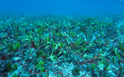
Halimeda bioherms on the Great Barrier Reef
The calcareous green alga Halimeda is a major contributor to inter-reef carbonate sediments and is found along the northern Great Barrier Reef shelf as extensive build-ups of sediment, called bioherms. Halimeda algae meadow (credit Emma Kennedy)These Halimeda bioherms...
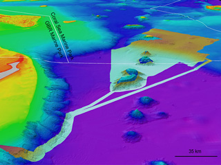
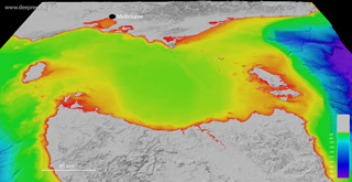
Crowdsourced bathymetry on the Great Barrier Reef
Crowdsourced bathymetry is the collection of depth measurements from vessels using standard navigation instruments. Many vessels on the Great Barrier Reef - from dive boats to fishing boats - use some type of echo sounder to measure the depth of water. Combined with...
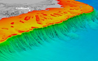
Submarine canyons of north-eastern Australia
Submarine canyons are among the largest undersea landscape features on Earth, and act as pathways for most of the terrigenous and carbonate sediment transported from the continents to the deep-sea. Canyons are typically associated with large submarine fans and gravity...
Rob’s Blog
Recent ocean mapping events within Australia’s marine region.
Member of the Order of Australia (AM)
I am incredibly honoured to be appointed a Member of the Order of Australia (AM) in The King's 2026 Honours List, for significant service to marine geology, ocean mapping, and geomorphology. The Chair of the Council for the Order of Australia spoke of recipients going...

Schmidt Ocean Institute Science Impact Award
I am honoured to receive the 2026 Schmidt Ocean Institute Science Impact Award, and on behalf of all the people involved with the RV Falkor's Great Barrier Reef and Coral Sea expeditions. It was also great fun to catch up with the SOI team at Glasgow, Scotland during...

Coral Futures with Australian Geographic
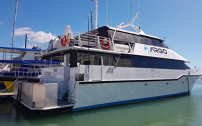
Had great week with the cruise expedition team and guests aboard MV Coral Discoverer, talking about Great Barrier Reef mapping, on the Coral Expeditions cruise 'Coral Futures with Australian Geographic'.MV Coral Discoverer on the GBRVideoAdditional Media The Forever...
Bathymetry
To view and download seafloor depth data in a range of media formats.

Williams Ridge bathymetry
This dataset provides the high-resolution bathymetry model for Williams Ridge, called the wr100 grid. The ~100 metre-resolution gridded bathymetry dataset covers an area of about 660,000 km2, which also includes parts of the Kerguelen Plateau. This page provides the...
Bass Strait bathymetry
This dataset provides the new high-resolution bathymetry model for the Bass Strait, called the bs100 grid. The ~100 metre-resolution gridded bathymetry dataset covers an area of about 334,000 km2, from King Island in the west of Bass Strait to Flinders Island in the...
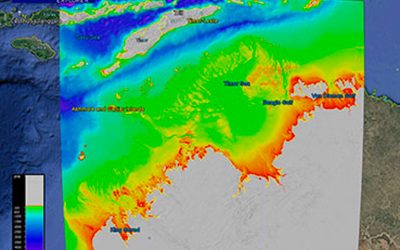
Northern Australia bathymetry
This dataset provides the new high-resolution bathymetry model for the Northern Australia, called the nthaus100 grid. The ~100 metre-resolution gridded bathymetry dataset covers an area of about 1,442,000 km, from Broome in Western Australia to Arnhem Land in the...
Publications
For a range of published literature, including in-depth scientific articles, reports and conference papers

Peer-reviewed Literature

Conference Papers

Book Sections

Reports

Magazine Articles
Dr Robin Beaman
Marine geologist and ocean mapping scientist revealing the underwater landscape.
Technology
Learn about the variety of tools used to study the ocean floor and water.
View Technology