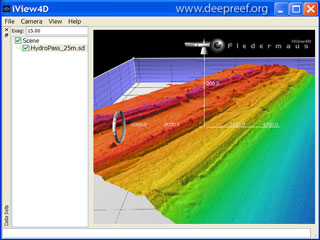
The 3D visualisation software we use is Fledermaus – a powerful, interactive 4D (space and time) data visualisation software developed by QPS. Fledermaus software is used for a variety of ocean mapping applications, such as multibeam depth editing, environmental surveys, undersea mining and seabed geology research.
 Example of Fledermaus 4D visualisation
Fledermaus software allows for intuitive exploration of geo-spatial data from a wide range of data formats, and includes time reference for users to work in a true 4D space and time environment. Data from remotely operated vehicles (ROVs), autonomous underwater vehicles (AUVs) and other vessel types can also be visualised in real-time, so the software is invaluable as an ocean mapping tool both at sea and onshore.
The Fledermaus visualisation software gives ocean mapping scientists a detailed view of the seafloor shape and depths. By using artificial sun-shading and colouring the depths using various colour maps, it is possible to highlight the subtle relief of the seabed and to quickly understand the variation in depths.
 Example of Fledermaus 4D visualisation
iView4D is a free viewer for files in the Fledermaus *.sd or *.scene file formats. Fledermaus scenes are larger files that contain a number of individual sd objects. The iView4D program contains only the basic viewing capabilities of Fledermaus software but has the following features:
- Easy to use widget based interface.
- Basic geo-spatial (location) information.
- Vertical exaggeration control.
- Show or hide sd objects in a scene.
- Support for split-screen stereo.
- Used on Windows XP/Vista, Linux, and Mac OS X.
- An OpenGL compatible video card is required.
The Gallery images and Movie below show examples of the seabed features in Australian and Antarctic waters, with geographic scales that vary from large ocean basins to the detailed local-scale. The colour maps used in the images were typically rainbow-coloured, with red for the shallowest depths ranging to violet for the deepest depths.
Gallery images

Seamount

Ribbon Reefs

Torres Strait

Iview4d Hydrodemo

Gebco

GBR Shelf

GBR Demo

Etopo2

Emily Reef

Drowned Reef

Canyons