
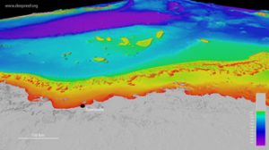
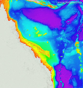
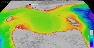
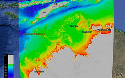
This dataset provides the high-resolution bathymetry model of the Great Barrier Reef, called gbr100, an output of Project 3D-GBR. The ~100 metre-resolution gridded bathymetry dataset covers an area of about 3,000,000 km2, from the Gulf of Papua to northern New South Wales, and easterly into the offshore Coral Sea. This page provides the data in a range of formats for public download.
NOT TO BE USED FOR NAVIGATION.
Additional content (xyz data, ESRI, GMT, Caris grids, Google Earth kml) can be obtained at the Geoscience Australia ecat website. Users can also access the AusSeabed Marine Data Portal to do Clip, Zip and Ship on the equivalent ‘Great Barrier Reef Bathymetry 2020 – 100m’ layer within Bathymetry-Compilations.
If using the data for publications, please quote the following reference:
- Beaman, R.J., 2010. Project 3D-GBR: A high-resolution depth model for the Great Barrier Reef and Coral Sea. Marine and Tropical Sciences Research Facility (MTSRF) Project 2.5i.1a Final Report, MTSRF, Cairns, Australia, pp. 13 plus Appendix 1. (internal link to report)


 |
|
GeoTIFF hillshade
 |
|
Grid data (V6 – 10 November 2020)
 |
|
Line data
 |
|
Metadata
You may also like…

Williams Ridge bathymetry
This dataset provides the high-resolution bathymetry model for Williams Ridge, called the wr100 grid. The ~100...
Bass Strait bathymetry
This dataset provides the new high-resolution bathymetry model for the Bass Strait, called the bs100 grid. The ~100...
Northern Australia bathymetry
This dataset provides the new high-resolution bathymetry model for the Northern Australia, called the nthaus100 grid....