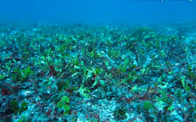
 Canyons offshore from CooktownThe submarine canyons of north-eastern Australia represent one of the most unexplored marine ecosystems of the deep Great Barrier Reef. The shelf edge between Cairns and Cooktown supports the world’s premier sports fishing for black marlin, which arrive annually to spawn and feed on food associated with upwelling from the canyons. Large areas of the northern GBR margin lying within the World Heritage Area were placed within Green ‘no-take’ zones, but with little knowledge of the detail and complexity of the submarine canyon ecosystems.
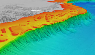
Since 2007, we have been mapping these submarine canyons using multibeam echosounders and subbottom profilers through the Marine National Facility and in collaboration with other vessels, such as the RV Sonne and RV Melville. The multibeam and seismic data reveal a spectacular network of canyons, slump scars and landslide deposits on the continental slope and deeper basins. These data provide a unique insight into the fundamental processes that have shaped the geological evolution of the GBR margin.
 Canyons offshore from CairnsWe see numerous (over 100) V-shaped canyons incising the slope, suggesting that active erosion has taken place over a distance of at least 400 km. Tension cracks and smaller feeder canyons around the heads of the canyons are observed at depths of 200-300 m depth. The canyons often terminate in slide scarps and debris fields where progressive upslope erosion has reduced the stability of the parent margin sediments. Offshore from Cairns, the canyons drop over 1000 m in depth to the floor of the Queensland Trough. Offshore from Cooktown, the canyons drop over 2000 m in depth.
Many canyons lie just to seaward of the outer-shelf barrier reefs, called the Ribbon Reefs. But in certain places, some canyons actually incise the continental shelf at the inter-reef passages between the barrier reefs. These shelf incising canyons appear to be the most active, with sonar backscatter maps revealing high reflectance pixels of coarse-grained, shallow-water coral sediments being transported into the deeper basins as gravity flows, or turbidites, to depths of about 2 km.
These datasets are being used to expand our basic understanding of how the north-eastern Australia margin has evolved over time, and the role of these canyons in transporting sediment into the deep-sea. For example, we are using previously collected deep sediment cores to understand the responses of the GBR to past climate change and sea-level variation. The detailed 3D maps will also help us to target areas in future expeditions to better understand the deep marine ecosystems associated with these canyons.
Movie
Map
- Peer-reviewed literature – Morphology and controls on the evolution of a mixed carbonate-siliciclastic submarine canyon system
- Peer-reviewed literature – Variation in canyon morphology on the Great Barrier Reef margin
- Peer-reviewed literature – A 60 ky record of mixed carbonate-siliciclastic turbidite deposition from the Great Barrier Reef
- Related blog post – Secrets of the Great Barrier Reef submarine canyons
- Peer-reviewed literature – Late Pleistocene history of turbidite sedimentation in a submarine canyon