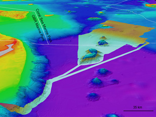
When does singlebeam echo sounder data start looking like multibeam data? In this 3D view of the seafloor at North Keppel Island, Great Barrier Reef, dense lines of crowdsourced bathymetry data reveal ~2.5 m high underwater dunes (profile is 1 km long).
Thanks to the North Keppel Island Environmental Education Centre vessel ‘Gundoo Spirit’

Underwater dunes