
Bathymetry

Williams Ridge bathymetry
This dataset provides the high-resolution bathymetry model for Williams Ridge, called the wr100 grid. The ~100 metre-resolution gridded bathymetry dataset covers an area of about 660,000 km2, which also includes parts of the Kerguelen Plateau. This page provides the...
Bass Strait bathymetry
This dataset provides the new high-resolution bathymetry model for the Bass Strait, called the bs100 grid. The ~100 metre-resolution gridded bathymetry dataset covers an area of about 334,000 km2, from King Island in the west of Bass Strait to Flinders Island in the...
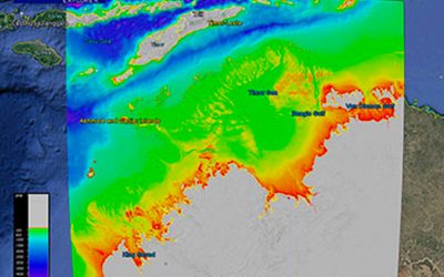
Northern Australia bathymetry
This dataset provides the new high-resolution bathymetry model for the Northern Australia, called the nthaus100 grid. The ~100 metre-resolution gridded bathymetry dataset covers an area of about 1,442,000 km, from Broome in Western Australia to Arnhem Land in the...

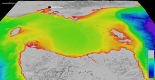
Kerguelen Plateau bathymetry
This dataset provides the high-resolution bathymetry model for the Kerguelen Plateau, called the kerg100 grid. The ~100 metre-resolution gridded bathymetry dataset covers an area of about 736,000 km2, which also includes the land elevation coverage for Heard Island...
George V Land bathymetry
This dataset provides the high-resolution bathymetry model for the Terre Adelie and George V continental margin, East Antarctica, called gvdem (short for George V digital elevation model). The ~100 metre-resolution gridded bathymetry dataset covers an area of about...

Great Barrier Reef bathymetry
This dataset provides the high-resolution bathymetry model of the Great Barrier Reef, called gbr100, an output of Project 3D-GBR. The ~100 metre-resolution gridded bathymetry dataset covers an area of about 3,000,000 km2, from the Gulf of Papua to northern New South...