
Biography
Dr Robin Beaman
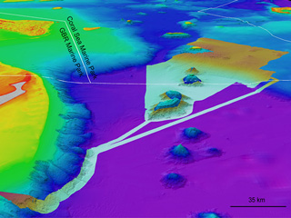
My role as a marine geologist and ocean mapping scientist is to reveal Australia’s underwater landscape. Ocean mapping helps to improve understanding of the geological origin of the seafloor, and explain the distribution of seabed habitats and marine life.
My research goal is to understand the long-term geological and physical processes that have influenced key geomorphic features of the seabed, particularly for the deep Great Barrier Reef and the Coral Sea.
Research projects range from submarine canyons, underwater landslides, submerged reefs, paleo-channels, algal bioherms, cold-water corals, mesophotic (twilight) coral ecosystems, seamounts and habitat mapping.
These projects use GIS, multibeam and singlebeam echo sounders, lidar, sidescan sonar, sub-bottom profilers, photogrammetry, underwater camera imagery, satellite imagery and sediment sampling techniques.
I want to share with you the excitement of scientific discovery in the ocean, and help to promote a more ocean-aware community through this website. Please contact me directly if you want more information about our research projects.
Rob’s Blog
Recent ocean mapping events within Australia’s marine region.
Member of the Order of Australia (AM)
I am incredibly honoured to be appointed a Member of the Order of Australia (AM) in The King's 2026 Honours List, for significant service to marine geology, ocean mapping, and geomorphology. The Chair of the Council for the Order of Australia spoke of recipients going...

Schmidt Ocean Institute Science Impact Award
I am honoured to receive the 2026 Schmidt Ocean Institute Science Impact Award, and on behalf of all the people involved with the RV Falkor's Great Barrier Reef and Coral Sea expeditions. It was also great fun to catch up with the SOI team at Glasgow, Scotland during...

Coral Futures with Australian Geographic
Had great week with the cruise expedition team and guests aboard MV Coral Discoverer, talking about Great Barrier Reef mapping, on the Coral Expeditions cruise 'Coral Futures with Australian Geographic'.MV Coral Discoverer on the GBRVideoAdditional Media The Forever...