
Biography
Dr Robin Beaman
My role as a marine geologist and ocean mapping scientist is to reveal Australia’s underwater landscape. Ocean mapping helps to improve understanding of the geological origin of the seafloor, and explain the distribution of seabed habitats and marine life.
My research goal is to understand the long-term geological and physical processes that have influenced key geomorphic features of the seabed, particularly for the deep Great Barrier Reef and the Coral Sea.
Research projects range from submarine canyons, underwater landslides, submerged reefs, paleo-channels, algal bioherms, cold-water corals, mesophotic (twilight) coral ecosystems, seamounts and habitat mapping.
These projects use GIS, multibeam and singlebeam echo sounders, lidar, sidescan sonar, sub-bottom profilers, photogrammetry, underwater camera imagery, satellite imagery and sediment sampling techniques.
I want to share with you the excitement of scientific discovery in the ocean, and help to promote a more ocean-aware community through this website. Please contact me directly if you want more information about our research projects.
Rob’s Blog
Recent ocean mapping events within Australia’s marine region.
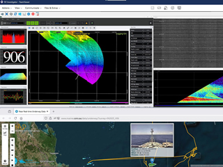
The Coral Sea frontier expedition
What's more fun than streaming your latest TV shows? The live streaming of multibeam seafloor mapping by Australia's dedicated blue-water research vessel Investigator in the Coral Sea Marine Park. With licenced and free software installed ashore and aboard,...
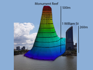
Newly named Monument Reef
Australia's Great Barrier Reef has a newly named reef, Monument Reef, gazetted by the Queensland Government on 31 Oct 2025. This 500m-tall reef was named for the towering limestone (monument-like) monolith. Many thanks to Kari and the team from Department of Natural...

Whale sharks aggregate in Great Barrier Reef
Did you know whale sharks aggregate in Australia's Great Barrier Reef? Our latest research on Rhincodon typus, led by Ingo Miller, identifies Wreck Bay as a key habitat with peak aggregation from late-Nov to late-Dec. Satellite-tagging shows movements concentrated...