
Rob’s Blog
Recent ocean mapping events within Australia’s marine region.
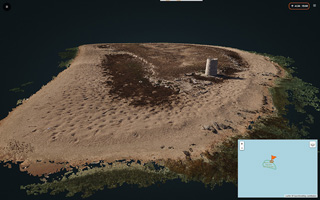
Visualising 3D point clouds in PointBox
With the proliferation of 3D point clouds generated by terrestrial and bathymetric lidar, multibeam sonar and photogrammetry methods, the visualising of these 3D point clouds online is becoming more important for end-users, and easier. 3D point cloud of Raine...
Aboriginal settlement in Australia was no accident
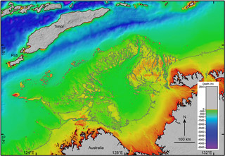
James Cook University researchers working to solve the mystery of how Aboriginal people first reached Australia say the earliest people didn’t get here by accident, but made deliberate voyages to reach the new land. NW Australia with -75 m coastlineScientists have...

Undersea maps reveal GBR in unprecedented detail
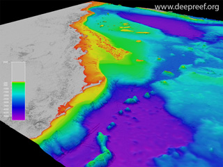
High-resolution seafloor maps released today show 1.5 million square kilometres of Australia’s iconic Great Barrier Reef in unprecedented detail. Hook and Line Reefs, central GBRThe maps are the product of a collaborative project between James Cook University,...
Map the Gaps, a GEBCO Symposium on Bathymetry
This week was the very successful Map the Gaps, a GEBCO Symposium on Bathymetry, held in Busan, South Korea. The symposium theme was "The world’s oceans are being mapped, one sounding at a time. Join us and hear from technologists, innovators, researchers and makers...
Mapping the Great Barrier Reef with cameras, drones and NASA tech
New and old technologies reveal what's killing Australia's great marine wonder. 3D view of the Great Barrier ReefRead the full story "Mapping the Great Barrier Reef with cameras, drones and NASA tech", published by CNET on 19 October 2017. Dr Robin Beaman from James...
Navy’s SeaBat T50-R multibeam sea trial
The Royal Australian Navy's Hydrographic Ships Leeuwin and Melville are based in Cairns, North Queensland. These 71 m long ships enable the Australian Hydrographic Service to collect high-quality bathymetry data within Australia's regional seas. I was invited onboard...

JCU Brighter – Charting the unknown
Explorers no longer take to the skies or travel to distant lands to discover the unknown, instead they look to the depths of the Great Barrier Reef (GBR) Marine Park. While we can see almost every corner of the globe thanks to Google Earth, beneath the ocean’s surface...
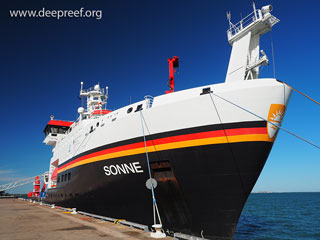
RV Sonne expedition along the GBR margin
The German RV Sonne is one of the world’s largest deep ocean research vessels. She was built in 2014 with a length of 118 m, breadth of 23 m and gross tonnage of 8554. She sails the world's oceans in search of cutting-edge science and we have just completed an...

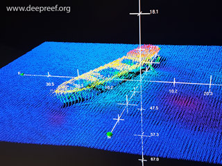
Yongala 3D wreck photogrammetry
The SS Yongala sank in 1911 during a cyclone near Cape Bowling Green in the central Great Barrier Reef. The wreck is about 100 m long lying on a flat seafloor in 26 m of water. The Yongala is one of the world's top dive destinations as the wreck provides a complex...