Aquatic remote sensing company EOMAP, together with researchers from James Cook University, the University of Queensland and the Cooperative Research Centre for Spatial Information, have processed historical satellite data to derive a set of groundbreaking, high resolution, shallow water topography maps for the entire Great Barrier Reef.
 These world-first digital maps, are a critical step towards identifying, managing and essentially preserving and protecting what lies within the waters of this global icon.
Project partner, Dr Robin Beaman of James Cook University, says the products are different to anything else available, as until now, nearly half of the shallow water reef areas on the Great Barrier Reef were not mapped using modern digital surveys. While these coral reefs are the most ecologically significant, they are also the most difficult to map due to being either too remote or because of their shallow nature, which makes them navigationally dangerous.
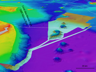
Instead of relying on traditional surveying vessels or aircraft to map the many ‘un-mappable’ areas of the reef, EOMAP used space-borne satellites to overcome these hurdles. The result is the largest project of its kind ever conducted in Australia, and possibly the entire world. The 3D water depth maps have a 30 m horizontal resolution over approximately 350,000 km2 of the Great Barrier Reef World Heritage Area and Torres Strait, providing not only more detailed individual reef data, but also a complete picture of Earth’s largest coral reef ecosystem.
“This information is regarded as essential for any government or company involved with managing the reef environment,” states Professor Stuart Phinn, University of Queensland, another partner on the project.
 The product will aid ‘big picture’ assessments of the Great Barrier Reef including water quality modeling, measuring responses to both man-made and natural impacts, such as sediment transportation and tropical cyclones, and helping to predict the likely impacts of climate change effects, such as sea level rise and increased tropical cyclone frequency. It will also help target priority areas for more detailed data collection, for example with the vast improvements this promises to ocean current modeling, scientists can model crown of thorn starfish larval trajectories to where they are next likely to inhabit the Great Barrier Reef.
“There is often a disconnect between research and industry, where researchers generally look at changes on individual reefs and habitats,” comments Dr Nathan Quadros from the Cooperative Research Centre for Spatial Information, also a partner on the project. “But industry want the overall picture of the reef – this product brings the two together.”
All of the mapped areas, no matter how small, are available for purchase by anyone via the EOMAP website. A coarser data product (500 m spatial resolution) is also available, free of charge, together with sample data of the high resolution products.
Movie
Additional media