A James Cook University project to develop a high-resolution depth model for the Great Barrier Reef and Coral Sea has taken out the honours at the Queensland Spatial Excellence Awards presented by the Spatial Industries Business Association.
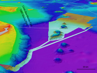
Project 3DGBR leader Dr Robin Beaman received the J. M. (Mac) Seriser Award for the nomination with the highest level of overall excellence and the Environment and Sustainability Award for a 100m-resolution digital elevation model for the Great Barrier Reef and Coral Sea called the ‘gbr100’ grid.
A marine geologist at JCU’s College of Science, Technology and Engineering, Dr Beaman was nominated by the Queensland Cyber Infrastructure Foundation as the grid is generated with help from the JCU High Performance Computing facilities in Townsville.
“The grid has been used by industry, government and research institutes, as well as the general public for understanding many issues on the Great Barrier Reef, such as freshwater plume tracking, seabed habitat and storm surge modelling,” Dr Beaman said.
“Nearly every week I receive a call with a new idea on how the grid can be used and many of these applications go far beyond my imagination for its use.
“The grid of the seafloor allows the stripping back of the water so people can get a sense of how complex the Great Barrier Reef is. It is a great honour to be able to show the 3D underwater landscape of the biggest coral reef system in the world.
“We are currently working on version 3 of the gbr100 grid to be released later this year and it will better reflect the reality of the seabed.
“Our techniques are constantly improving as we are working with more partners to give a greater coverage of source data and more surveys have been done, especially in the deeper parts of the Great Barrier Reef.
“The awards recognise all the hard work which has gone into the project in the past five years and will continue to go in to it as more mapping of the seabed is done.
“Many people have been involved, from larger organisations including the Royal Australian Navy and Geoscience Australia, to the many smaller companies and agencies up and down the coast such as individual businesses and port authorities.
“They all have buy-in and understand the importance of the project and that is the real strength of this model because it includes all of their data.”
Project 3DGBR was originally funded through a Queensland Government Smart Future Fellowship, JCU and Reef and Rainforest Research Centre co-funding.