
Rob’s Blog
Recent ocean mapping events within Australia’s marine region.
The Coral Sea frontier expedition
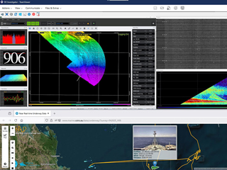
What's more fun than streaming your latest TV shows? The live streaming of multibeam seafloor mapping by Australia's dedicated blue-water research vessel Investigator in the Coral Sea Marine Park. With licenced and free software installed ashore and aboard,...
Newly named Monument Reef
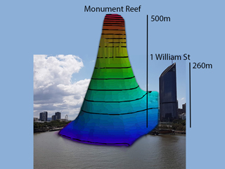
Australia's Great Barrier Reef has a newly named reef, Monument Reef, gazetted by the Queensland Government on 31 Oct 2025. This 500m-tall reef was named for the towering limestone (monument-like) monolith. Many thanks to Kari and the team from Department of Natural...

Whale sharks aggregate in Great Barrier Reef
Did you know whale sharks aggregate in Australia's Great Barrier Reef? Our latest research on Rhincodon typus, led by Ingo Miller, identifies Wreck Bay as a key habitat with peak aggregation from late-Nov to late-Dec. Satellite-tagging shows movements concentrated...

David Attenborough’s 99th birthday
Happy 99th birthday Sir David Attenborough. Here is us together on MV Alucia in Cairns, Australia during the filming of 'David Attenborough’s Great Barrier Reef' in 2014. Looking forward to seeing 'Ocean with David Attenborough'.Sir David and me onboard MV AluciaVideo

How to name a reef
How do you name a reef in the Great Barrier Reef? One way is to propose a name to the Queensland Government, responsible for naming reefs lying within Coastal Waters on the GBR. Here, we propose 'Monument Reef' for the spectacular 500m-tall detached reef discovered...

CSB on the Great Barrier Reef: Project update
On 28 March 2025, I presented a remote talk: 'Crowdsourced bathymetry on the Great Barrier Reef: Project update', at the IHO Crowdsourced Bathymetry Working Group Meeting 16, held in Wellington New Zealand.Vessel traffic in the Great Barrier ReefAdditional Media...

Report for expedition: Visioning the Coral Sea Marine Park
What does a month and half of continuous mapping around Australia's Coral Sea Marine Park with the Schmidt Ocean Institute’s RV Falkor look like? The first complete maps around the steep flanks of all 30 reefs on the Queensland Plateau.3D view of the Coral Sea Marine...

SI 1047 survey in Queensland Plateau
Protecting our shores - congratulations to the Australian Hydrographic Office and EGS Survey for commencing the survey SI 1047, in Australia’s Coral Sea Marine Park. This SI 1047 multibeam survey was proposed following the mapping by the Schmidt Ocean Institute's RV...

Crowdsourced bathy data from Spoilsport
Another successful batch of crowdsourced bathymetry data from adventure dive vessel MV Spoilsport, collected over 100s of line km on the northern Great Barrier Reef, Australia. Next steps: remove tidal component and 'no bottom detection' soundings, then revise 3D...