
Rob’s Blog
Recent ocean mapping events within Australia’s marine region.
3D Reef map project scoops awards
A James Cook University project to develop a high-resolution depth model for the Great Barrier Reef and Coral Sea has taken out the honours at the Queensland Spatial Excellence Awards presented by the Spatial Industries Business Association. Project 3DGBR leader Dr...
Mapping the great unknown: the ocean floor
The disappearance of MH370 has highlighted just how little we know about the ocean floor. Yet the race is on to map, and even Google Street View, the three quarters of the Earth’s surface that lies beneath the waves. Read the full article "Mapping the great unknown:...
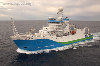
Australia’s new RV Investigator arrives in Hobart
Australia's new blue-water research vessel, RV Investigator, completes its delivery voyage from Singapore to Hobart today. In 2009, the Australian Government allocated $120 million for a new ocean-going research vessel to replace the old Marine National Facility, the...
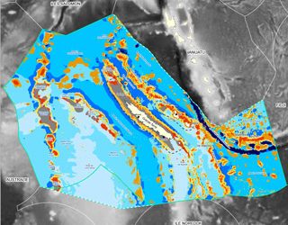
Geomorphological characterisation of New Caledonia
In the seas around New Caledonia, geomorphological features of the seafloor (e.g. banks, atolls and seamounts) are sites of outstanding marine biodiversity, studied by local research initiatives such as the ZoNeCo program to assess the living and non-living marine...

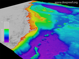
Marine geologist unlocks secrets of the Great Barrier Reef
Dr Robin Beaman may well be a modern-day James Cook. The marine geologist has dedicated the past 14 years to mapping uncharted territories, discovering new marine life, ancient corals and obscure underwater landscapes along the way. His research is redefining...
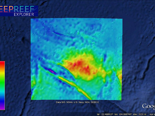
Zenith Plateau as the final resting place for MH370?
The underwater search for the missing Malaysia Airlines MH370 has become focused on the Zenith Plateau in the eastern Indian Ocean, lying about 1000 km to its nearest point on the Western Australia coast, or 1685 km north-west of Perth. The plateau is surrounded by...
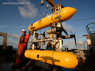
Autonomous underwater vehicle on the Great Barrier Reef
The Australian Centre for Field Robotics (ACFR) conducts numerous expeditions around Australia using their Sirius autonomous underwater vehicle (AUV). Here is a recent video captured by a GoPro mounted on the AUV while on a research expedition to the Great Barrier...
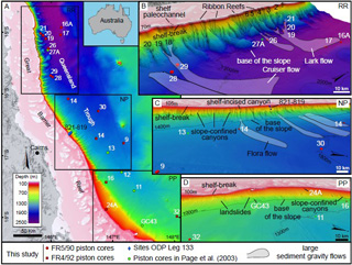
Secrets of the Great Barrier Reef submarine canyons
Vast undersea canyons are giving scientists insight into the ancient history of the Great Barrier Reef, and how it has responded to past climate change. “Beyond the familiar coral reefs of the Great Barrier Reef Marine Park are deep basins and troughs, as deep as...

‘Unmappable’ Great Barrier Reef mapped
Aquatic remote sensing company EOMAP, together with researchers from James Cook University, the University of Queensland and the Cooperative Research Centre for Spatial Information, have processed historical satellite data to derive a set of groundbreaking, high...