
Rob’s Blog
Recent ocean mapping events within Australia’s marine region.
RV Investigator maps northern Great Barrier Reef
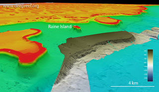
A transit voyage by CSIRO research vessel (RV) Investigator to reposition the vessel from Cairns to Darwin (IN2022_T01), was an opportunity to continue multibeam mapping along the far northern Great Barrier Reef continental margin. Dr Robin Beaman from James Cook...

New reef to be named
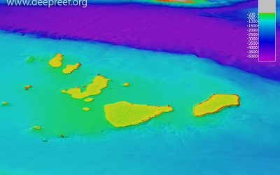
A 500 metre-tall reef discovered two years ago by ocean scientists is set to be formally named, sharing its name with a ship and a dragon from a classic fantasy movie. James Cook University’s Dr Robin Beaman, who helped lead the Northern Depths of the Great Barrier...
Project HALO 2022 sails on RV Investigator
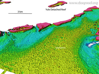
Project HALO 2022 has started with Australia's Marine National Facility RV Investigator sailing to the northern Great Barrier Reef with an international science team, to study Halimeda (calcareous green algae) sediment mounds - the largest such bioherms in the world....
Bass Strait bathymetry compilation
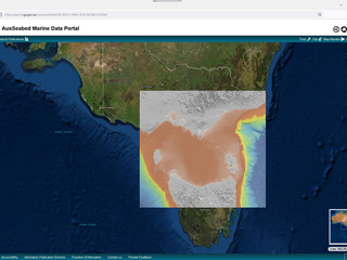
The 'Bass Strait Bathymetry 2022 30m' grid has been released on the AusSeabed Marine Data Portal as a bathymetry compilation of available source data. Many thanks to Geoscience Australia, the Australian Hydrographic Office, CSIRO's Marine National Facility and Deakin...

High-tech seafloor mapping is finding surprising structures everywhere
The August 2022 issue of Scientific American magazine features the newly discovered 500 m tall coral reef from the Great Barrier Reef in 'High-tech seafloor mapping is finding surprising structures everywhere' Thanks to Mark Fischetti (Scientific American), Maciej...
RV Sonne survey of Queensland Plateau
One of the world’s largest research vessels, Germany’s RV Sonne, has completed a month-long marine science expedition (SO292) to the Queensland Plateau conducting multibeam surveying, sub-bottom profiling and underwater camera transects around these giant coral...
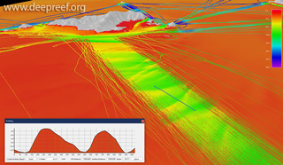
Crowdsourced bathy data reveals underwater dunes
When does singlebeam echo sounder data start looking like multibeam data? In this 3D view of the seafloor at North Keppel Island, Great Barrier Reef, dense lines of crowdsourced bathymetry data reveal ~2.5 m high underwater dunes (profile is 1 km long). Thanks to the...

Queensland wrecks photo gallery
There are some 1000+ wrecks in Queensland waters and on the Great Barrier Reef. Here is a photo gallery collection of wrecks revealed through high-resolution multibeam sonar, sidescan sonar and photogrammetry. Many thanks to all those mapping specialists who provided...
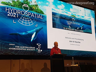
Hydrospatial 2021 Conference live in Cairns, Australia
In a very welcome return to live meetings, the Hydrospatial 2021 Conference was held in Cairns, Australia, from 16-18 Feb 2022 after being delayed since 2021. The theme of the conference was 'Hydrography of the Future'. John Maschke, Conference Director, together with...