
Rob’s Blog
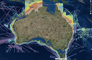
Recent ocean mapping events within Australia’s marine region.

Citizen scientists to help map the Reef
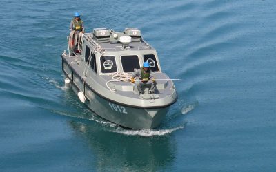
James Cook University is calling for volunteers to help map the seafloor around the Great Barrier Reef to better protect the natural icon. MV ARGO volunteer vessel in CairnsJCU marine geologist Dr Robin Beaman said the Royal Australian Navy does great work mapping the...
Seeing more of Australia’s seafloor
Fields of hidden volcanoes, canyons that cut through the continental shelf and oceanic plateaus that rise more than a thousand metres from the deep sea to the surface are just some of the features revealed in never-before-seen detail by new high-resolution bathymetry...
GEBCO Symposium in Canberra
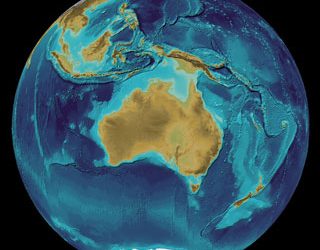
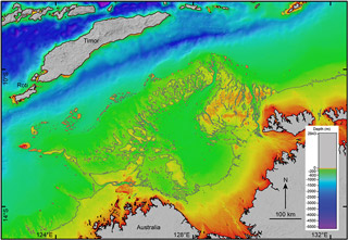
The annual Map the Gaps GEBCO Symposium on Bathymetry was held in Canberra, and hosted by Geoscience Australia and Land Information New Zealand. bathymetry of Australia region, GEBCO grid Two days of meetings preceded the Symposium, for the GEBCO Technical...
The Future of Hydrography
Fugro, a global offshore and onshore geotechnical and survey services company, has developed an excellent YouTube video called 'The Future of Hydrography'. Additional media Hydro 2018 Conference and Trade Exhibition in Sydney on 30 Oct to 1 Nov 2018 GEBCO Symposium in...
Visualising 3D point clouds in PointBox
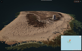
With the proliferation of 3D point clouds generated by terrestrial and bathymetric lidar, multibeam sonar and photogrammetry methods, the visualising of these 3D point clouds online is becoming more important for end-users, and easier. 3D point cloud of Raine...
Aboriginal settlement in Australia was no accident
James Cook University researchers working to solve the mystery of how Aboriginal people first reached Australia say the earliest people didn’t get here by accident, but made deliberate voyages to reach the new land. NW Australia with -75 m coastlineScientists have...

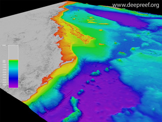
Undersea maps reveal GBR in unprecedented detail
High-resolution seafloor maps released today show 1.5 million square kilometres of Australia’s iconic Great Barrier Reef in unprecedented detail. Hook and Line Reefs, central GBRThe maps are the product of a collaborative project between James Cook University,...
Map the Gaps, a GEBCO Symposium on Bathymetry
This week was the very successful Map the Gaps, a GEBCO Symposium on Bathymetry, held in Busan, South Korea. The symposium theme was "The world’s oceans are being mapped, one sounding at a time. Join us and hear from technologists, innovators, researchers and makers...
Mapping the Great Barrier Reef with cameras, drones and NASA tech
New and old technologies reveal what's killing Australia's great marine wonder. 3D view of the Great Barrier ReefRead the full story "Mapping the Great Barrier Reef with cameras, drones and NASA tech", published by CNET on 19 October 2017. Dr Robin Beaman from James...