Drowned (or submerged) reefs are coral reefs that grew during lower sea-levels, and they now lie in depths greater than those typically associated with the vigorous growth of modern coral reefs. Studies around the world have found that drowned reefs are very important as habitats for mesophotic (twilight zone) marine life, and as records of environmental change as the corals that grew earlier are now preserved in the limestone rock of the drowned reefs.
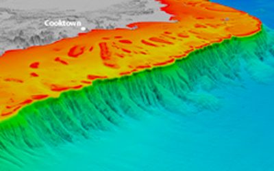
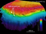
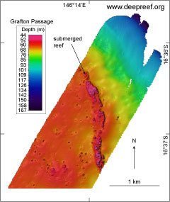 3D view of drowned reefOn the Great Barrier Reef, an extensive line of drowned reefs are found along the shelf-edge in depths of about 40 to 70 m. These drowned reefs lie in deeper waters compared to the shallow reefs that people see when they visit the Great Barrier Reef. Pioneering research in the 1980s and 1990s looking for drowned reefs found they were narrow in width, just a few 100s of m wide, and run parallel with the shelf break where the edge of the shelf meets the continental slope.
We had obtained new multibeam bathymetry (depth) data collected by the Royal Australian Navy and could see the drowned reefs in greater detail than ever viewed before. This project was started to answer questions, such as how extensive are these features, what are their range of depths, what could they tell us about previous climate and sea-level history of the reef, and what marine animals and plants are now living on the drowned reefs?
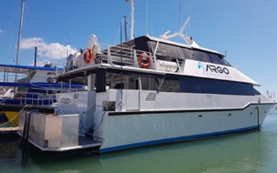
In 2007, we conducted an expedition on the Australia’s Marine National Facility vessel, the RV Southern Surveyor, called ‘Evolution of drowned shelf edge reefs in the GBR: Implications for understanding abrupt climate change, coral reef response, and modern deep water benthic habitats’. We received a National Geographic Committee for Research and Exploration and ECORD grants to help pay for the expedition.
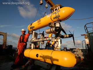 autonomous underwater vehicleScientists and students with an interest in drowned reefs were invited to the expedition from James Cook University, University of Sydney, University of Oxford and the University of Edinburgh. The ship departed from Cairns in north Queensland and traveled along edge of the GBR outer-shelf and in the Coral Sea for about 700 km before finishing at Mackay in central Queensland.
We used a Kongsberg EM300 multibeam echosounder and a Topas PS18 sub-bottom profiler, which use various sound frequencies to explore the seafloor and provide us with a detailed 3D view of the underwater landscape. Computer visualisation software gave us the ability to ‘glide’ through the seascape so we could closely examine the shape of the seabed.
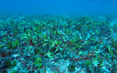
Once the drowned reefs were located, we sent down an autonomous underwater vehicle from the Australian Centre for Field Robotics. The AUV robot was not tethered by a cable to the ship and could operate by itself after being programmed with directions for where to find the reefs. The AUV could operate closely over the seafloor taking stereo photos of the marine life living on and around the drowned reefs.
The data from this expedition and other voyages, such as IODP Expedition 325, are now providing scientists with valuable records of the past response of the Great Barrier Reef to climate and sea-level change. These detailed 3D seabed maps and images of the seafloor also help us to understand how these reefs provide a deep habitat for present marine life. This new information will also help the Marine Park managers to protect and preserve these deeper reef environments.
Gallery Images

Operations Room

Science Crew

AUV
Soft Corals
Escape Pass

GBR margin

Shelfedge Northern GBR
Shelfedge Southern GBR

Drowned Reef Ribbon 5 Reef

Drowned Reef Hydro Pass

Drowned Reef Osprey Reef

Soft Corals
Movie
Map
Additional media
- Report – Voyage Summary Report
- Peer-reviewed literature – From corals to canyons: The Great Barrier Reef margin
- Peer-reviewed literature – AUV-assisted surveying of drowned reefs on the shelf edge of the Great Barrier Reef, Australia
- Peer-reviewed literature – Topography, substratum and benthic macrofaunal relationships on a tropical mesophotic shelf margin
- Related blog post – IODP Expedition 325