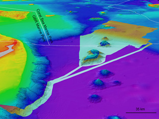
A new 3D bathymetry (depth) model of the Great Barrier Reef and Coral Sea at ~100 m resolution, called ‘gbr100’, is now available at the gbr100 download page.
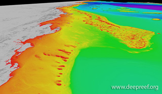 New 3D depth model for the GBRThis revised 3D depth model (V6 – 10 Nov 2020) is a significant improvement on the previous 2017 version, with all offshore reefs mapped with either airborne lidar bathymetry surveys or satellite derived bathymetry. All the available processed multibeam data are now included. Crowdsourced singlebeam bathymetry adds over 50 thousand line km of source data to the inter-reef seafloor. Work will continue to fill the gaps.
The integrated 3D depth model uses a WGS84 geographic horizontal datum and approximates a MSL vertical datum. The ~100 m pixel resolution can only resolve seabed features larger than 100 m in size. The model area stretches from 10° South in the Torres Strait to 29° South in northern NSW, along the entire Queensland coast.
GIS users may wish to download the data as ESRI raster, floating point geotiff or GMT/netCDF files.
Non-GIS users may prefer to download the Google Earth Bathymetry hillshade layer or Fledermaus+iView4D files.
Many thanks to all who have contributed to this result. Some honourable mentions:
• Mark and Grant at Maritime Boundaries, Geoscience Australia
• Kim and the team from AusSeabed, Geoscience Australia
• Stuart and the GSM team from Australia’s Marine National Facility
• Joseph at the Great Barrier Reef Marine Park Authority
• Mark and the team from Royal Australian Navy LADS Flight
• Captains and crew from Schmidt Ocean Institute’s RV Falkor
• Masters and crew from the crowdsource bathymetry volunteer vessels
• Anne and Scott at the Australian Hydrographic Office
Additional media
New 3D depth model for the GBRThis revised 3D depth model (V6 – 10 Nov 2020) is a significant improvement on the previous 2017 version, with all offshore reefs mapped with either airborne lidar bathymetry surveys or satellite derived bathymetry. All the available processed multibeam data are now included. Crowdsourced singlebeam bathymetry adds over 50 thousand line km of source data to the inter-reef seafloor. Work will continue to fill the gaps.
The integrated 3D depth model uses a WGS84 geographic horizontal datum and approximates a MSL vertical datum. The ~100 m pixel resolution can only resolve seabed features larger than 100 m in size. The model area stretches from 10° South in the Torres Strait to 29° South in northern NSW, along the entire Queensland coast.
GIS users may wish to download the data as ESRI raster, floating point geotiff or GMT/netCDF files.
Non-GIS users may prefer to download the Google Earth Bathymetry hillshade layer or Fledermaus+iView4D files.
Many thanks to all who have contributed to this result. Some honourable mentions:
• Mark and Grant at Maritime Boundaries, Geoscience Australia
• Kim and the team from AusSeabed, Geoscience Australia
• Stuart and the GSM team from Australia’s Marine National Facility
• Joseph at the Great Barrier Reef Marine Park Authority
• Mark and the team from Royal Australian Navy LADS Flight
• Captains and crew from Schmidt Ocean Institute’s RV Falkor
• Masters and crew from the crowdsource bathymetry volunteer vessels
• Anne and Scott at the Australian Hydrographic Office
Additional media