
Rob’s Blog
Recent ocean mapping events within Australia’s marine region.
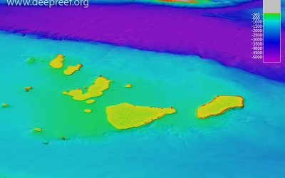
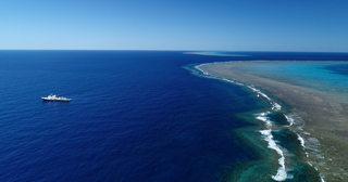
RV Sonne survey of Queensland Plateau
One of the world’s largest research vessels, Germany’s RV Sonne, has completed a month-long marine science expedition (SO292) to the Queensland Plateau conducting multibeam surveying, sub-bottom profiling and underwater camera transects around these giant coral...
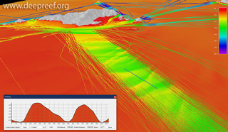
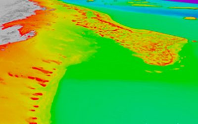
Crowdsourced bathy data reveals underwater dunes
When does singlebeam echo sounder data start looking like multibeam data? In this 3D view of the seafloor at North Keppel Island, Great Barrier Reef, dense lines of crowdsourced bathymetry data reveal ~2.5 m high underwater dunes (profile is 1 km long). Thanks to the...

Queensland wrecks photo gallery
There are some 1000+ wrecks in Queensland waters and on the Great Barrier Reef. Here is a photo gallery collection of wrecks revealed through high-resolution multibeam sonar, sidescan sonar and photogrammetry. Many thanks to all those mapping specialists who provided...
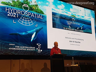
Hydrospatial 2021 Conference live in Cairns, Australia
In a very welcome return to live meetings, the Hydrospatial 2021 Conference was held in Cairns, Australia, from 16-18 Feb 2022 after being delayed since 2021. The theme of the conference was 'Hydrography of the Future'. John Maschke, Conference Director, together with...
Ocean Wonders exhibition
The Ocean Wonders exhibition has opened at Australian National Maritime Museum in Sydney. In 2020-21, Schmidt Ocean Institute collaborated with research institutions from across Australia and the globe to explore the deepest and most remote parts of the Australian...
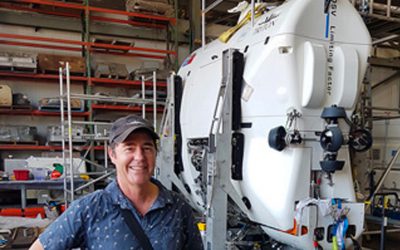
Collaboration with Caladan Oceanic in the Coral Sea
Fantastic to be collaborating with Caladan Oceanic to acquire new Kongsberg EM124 multibeam map data in the Coral Sea Marine Park during the ‘Ring of Fire Expedition Part II - South Pacific Trenches’ with the DSSV Pressure Drop and submersible Limiting Factor. DSV...
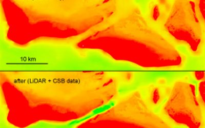
Crowdsourced bathymetry data improves 3D depth models
Crowdsourced bathymetry (CSB) data improve 3D depth models for Australia's Great Barrier Reef. Before and after 3D depth modelHere, fishing vessel MV Sharp Shooter's CSB data reveals the deeper channel between shallow reefs previously surveyed with airborne LiDAR...
Year of Falkor in the Great Barrier Reef
The RV Falkor has finally left Queensland waters after a full year working within the Great Barrier Reef and Coral Sea marine parks. With the ship now transiting across northern Australia towards Darwin, capital of the Northern Territory and the launchpad for the next...
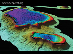
New 3D depth model of Great Barrier Reef and Coral Sea
A new 3D bathymetry (depth) model of the Great Barrier Reef and Coral Sea at ~100 m resolution, called ‘gbr100’, is now available at the gbr100 download page. New 3D depth model for the GBRThis revised 3D depth model (V6 – 10 Nov 2020) is a significant improvement on...